


 Follow Us
All-Sky Mapping of the UV Diffuse Radiation As Observed by GALEX
Murthy 2014, ApJS, 213, 32
|
|
|
|
|
 | 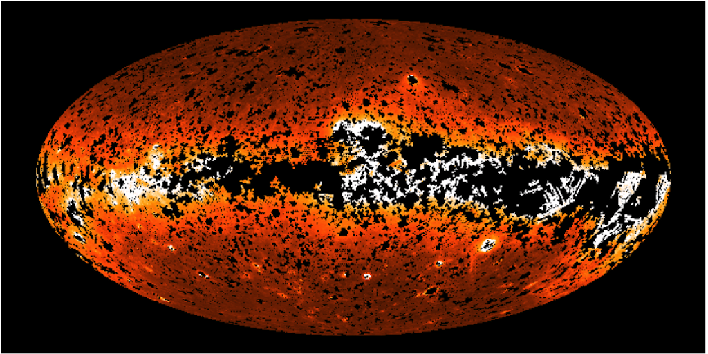 |
| Fig. 1: FUV diffuse radiation map. | Fig. 2: NUV diffuse radiation map. |
Introduction
Jayant Murthy has created maps of the diffuse UV radiation, in both FUV and NUV bands, using the latest GALEX all-sky data release (GR6+GR7). Tables are provided of the diffuse radiation for each GALEX visit at a resolution of 2 arcminutes, organized by galactic latitude. In addition to the diffuse background fluxes in NUV and FUV, he also provides estimates of the geocoronal and zodiacal foreground emissions for each binned pixel. A separate text table provides the estimated foreground corrections, at the observation (coadd) level, for each tile by taking the weighted average of the geocoronal and zodical emissions at the visit level. Aitoff projections of both the FUV and NUV diffuse radiation (and its variance), along with a 100-micron emission map based on the Schlegel et al. (1998) dust maps, are provided in FITS format. Finally, a table of GALEX spacecraft telemetry used to generate these data products is included. You can also visit Jayant's personal webpage for the project.
Data Format
FUV, NUV, and 100-micron Aitoff Projection FITS
The FITS headers and data format of the Aitoff projection files are summarized in this table (show / hide).
FUV and NUV Visit-Level Diffuse Background UV Tables
The columns of the visit-level diffuse background tables are summarized in this table (show / hide).
FUV and NUV Coadd-Level Foreground Tables
The columns of the coadd-level foreground tables are summarized in this table (show / hide).
Spacecraft Telemetry Table
The columns of the telemetry tables are summarized in this table (show / hide).
Data Access
The catalogs can be accessed as ASCII text files (see the table below), or through MAST's GALEX CasJobs page.
CasJobs
Here is an example SQL Query (make sure the Context drop-down menu is set to "GALEX_UV_BKGD" before running). This simple example selects those rows from a 1 square degree patch of sky that had some amount of binned NUV flux from the image file, and orders the resulting table by decreasing NUV_ORIG values.
	select * from background
	where glon > 0. and glon < 1.
	and glat > 45. and glat < 46.
	and nuv_orig > 0.
	order by nuv_orig DESC
Download Files (ASCII text tables, FITS files)
| Supplemental Data Products | |||
| Aitoff FITS files: FUV (~60 MB) NUV (~60 MB) Foreground table: FUV+NUV (~3 MB) Telemetry: Table (~330 MB) | |||
| Visit-Level Diffuse Background Tables | |||
| File | Min. Galactic Latitude |
Max. Galactic Latitude |
Approx. Size |
| hlsp_uv-bkgd_galex_diffuse_glat90-80S_fuv-nuv_v1_table.txt | -90 | -80 | 400 MB |
| hlsp_uv-bkgd_galex_diffuse_glat80-70S_fuv-nuv_v1_table.txt | -80 | -70 | 1.3 GB |
| hlsp_uv-bkgd_galex_diffuse_glat70-60S_fuv-nuv_v1_table.txt | -70 | -60 | 2.0 GB |
| hlsp_uv-bkgd_galex_diffuse_glat60-50S_fuv-nuv_v1_table.txt | -60 | -50 | 3.1 GB |
| hlsp_uv-bkgd_galex_diffuse_glat50-40S_fuv-nuv_v1_table.txt | -50 | -40 | 3.0 GB |
| hlsp_uv-bkgd_galex_diffuse_glat40-30S_fuv-nuv_v1_table.txt | -40 | -30 | 4.8 GB |
| hlsp_uv-bkgd_galex_diffuse_glat30-20S_fuv-nuv_v1_table.txt | -30 | -20 | 4.0 GB |
| hlsp_uv-bkgd_galex_diffuse_glat20-10S_fuv-nuv_v1_table.txt | -20 | -10 | 2.1 GB |
| hlsp_uv-bkgd_galex_diffuse_glat10-00S_fuv-nuv_v1_table.txt | -10 | +00 | 1.2 GB |
| hlsp_uv-bkgd_galex_diffuse_glat00-10N_fuv-nuv_v1_table.txt | +00 | +10 | 1.2 GB |
| hlsp_uv-bkgd_galex_diffuse_glat10-20N_fuv-nuv_v1_table.txt | +10 | +20 | 2.4 GB |
| hlsp_uv-bkgd_galex_diffuse_glat20-30N_fuv-nuv_v1_table.txt | +20 | +30 | 3.0 GB |
| hlsp_uv-bkgd_galex_diffuse_glat30-40N_fuv-nuv_v1_table.txt | +30 | +40 | 3.3 GB |
| hlsp_uv-bkgd_galex_diffuse_glat40-50N_fuv-nuv_v1_table.txt | +40 | +50 | 3.4 GB |
| hlsp_uv-bkgd_galex_diffuse_glat50-60N_fuv-nuv_v1_table.txt | +50 | +60 | 2.7 GB |
| hlsp_uv-bkgd_galex_diffuse_glat60-70N_fuv-nuv_v1_table.txt | +60 | +70 | 1.9 GB |
| hlsp_uv-bkgd_galex_diffuse_glat70-80N_fuv-nuv_v1_table.txt | +70 | +80 | 1.9 GB |
| hlsp_uv-bkgd_galex_diffuse_glat80-90N_fuv-nuv_v1_table.txt | +80 | +90 | 450 MB |
| 100-micron Emission Map | |||
| Aitoff FITS file: COBE+IRAS (~60 MB) Schlegel et al. 1998, ApJ, 500, 525 | |||
Software Tools For Use With Data
Jayant Murthy has provided some IDL programs to interact with these data. Per standard MAST policy, we will not actively support this software, but users are welcome to download and use this software on their own.
| IDL Software Accompanying The Data | |
| create_wcs_map.pro | Takes data returned from get_galex_hlsp_data and creates a map based on WCS coordinates. |
| get_galex_hlsp_data.pro | Reads data from diffuse background tables into a return structure, given a galactic coordinate and a search radius. |
| get_galex_hlsp_telemetry.pro | Finds the closest telemetry data and returns it as a structure, given an observation date. |
Back To Top
|
|
|